Index of Hungarian orienteering maps
-
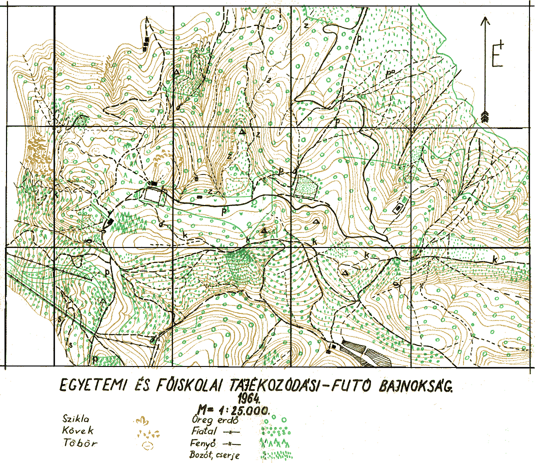
The first Hungarian color orienteering map surveyed specially for orienteering (Fehérkőlápa, 1964 - made by Endre Kővári) - 194 kB
-
-
 Table
of o-maps - 2010
Table
of o-maps - 2010
 Table
of o-maps - 2009
Table
of o-maps - 2009
 Table
of o-maps - 2008
Table
of o-maps - 2008
 Table
of o-maps - 2007
Table
of o-maps - 2007
 Table
of o-maps - 2006
Table
of o-maps - 2006
 Table
of o-maps - 2005
Table
of o-maps - 2005
Table
of o-maps - 2004 (full list with sample images)
Table
of o-maps - 2003 (full list with sample images)
Clickable
map of the country showing the geographic distribution of all Hungarian o-maps
published in 2003 (the same sample images also available via this link)
 Table
of o-maps - 2002 (full list with sample images)
Table
of o-maps - 2002 (full list with sample images)
Clickable
map of the country showing the geographic distribution of all Hungarian o-maps
published in 2002 (the same sample images also available via this link)
 Table
of o-maps - 2001 (full list with sample images)
Table
of o-maps - 2001 (full list with sample images)
Clickable
map of the country showing the geographic distribution of all Hungarian o-maps
published in 2001 (the same sample images also available via this link)
Table of o-maps - 2000 (full list with sample images)
Clickable map of the country showing the geographic distribution of all Hungarian o-maps published in 2000 (the same sample images also available via this link)
 Table of o-maps - 1999 (full list with sample images)
Clickable map of the country showing the geographic distribution of all Hungarian o-maps published in 1999 (the same sample images also available via this link)
Table of o-maps - 1998 (full list with sample images)
Clickable map of the country (48 kB) showing
the geographic distribution of all Hungarian o-maps published in 1998 (the same sample images also available via this link)
Table of o-maps - 1997 (full list with sample images) -
Full list in Hungarian (1997)
Clickable map of the country (48 kB) showing
the geographic distribution of all Hungarian o-maps published in 1997 (the same sample images also available via this link)
Table of o-maps - 1996 (full list with sample images),
maps of the World University Orienteering Championships, Veszprém
Clickable map of the country (34 kB) showing
the geographic distribution of all Hungarian o-maps published in 1996 (the same sample images also available via this link).
Table of o-maps - 1995 (full list with sample images)
Clickable map of the country (37 kB) showing
the geographic distribution of all Hungarian o-maps published in 1995 (the same sample images also available via this link).
Only for graphic browsers!
Table of o-maps - 1994 (full list with sample images)
Clickable map of the country (37 kB) showing
the geographic distribution of all Hungarian o-maps published in 1994 (the same sample images also available via this link).
Table of o-maps - 1993 (full list with sample images)
Clickable map of the country (42 kB) showing
the geographic distribution of all Hungarian o-maps published in 1993 (the same sample images also available via this link).
 Back to the Hungarian Orienteering HomePage